
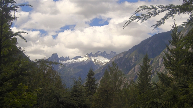
Introduction
North Cascades National Park is a stunning expanse of wilderness characterized by rugged peaks, lush forests, and a rich history that dates back thousands of years. Established on October 2, 1968, the park covers an area of approximately 504,654 acres (2,042.26 km²), making it one of the larger national parks in the United States. It includes a northern and southern section, bisected by the Skagit River, and is bordered by Ross Lake National Recreation Area and Lake Chelan National Recreation Area. The park's altitude ranges from 605 feet (184 m) at Goodell Creek to 9,220 feet (2,810 m) at Goode Mountain. This variation in elevation contributes to a diverse climate, with the western part of the park receiving heavy precipitation and fostering lush forests, while the eastern areas experience a rain shadow effect, leading to drier conditions. In 2021, the park had around 17,855 visitors, a number that is low but reflects the park's remote nature and limited accessibility
The region was first inhabited by Paleo-Indian Native Americans, with the Skagit tribes residing in the area by the time European American explorers arrived. The early 19th century saw fur trappers and traders from British and American companies exploring the region. The Canada–United States border was established at the 49th parallel in 1846, leading to further exploration for potential routes through the mountains.
The environmental impact began in the 1920s with the construction of several dams in the Skagit River valley for hydroelectric power. This led to campaigns by environmentalists to preserve the remaining wilderness, culminating in the designation of North Cascades National Park in 1968.
The park offers many attractions for visitors. Scenic drives along the North Cascades Highway provide breathtaking views, while trails like the Sterling Munro Trail and Diablo Lake Vista Point offer opportunities for hiking and wildlife viewing. The Washington Pass Overlook presents a panoramic view of the surrounding peaks, and the remote town of Stehekin serves as a gateway for further exploration into the park's interior.
North Cascades is home to a rich array of wildlife, including approximately 75 mammal species, 200 species of birds, 28 species of fish, and a vast number of invertebrates. Notable mammals include the elusive gray wolf, grizzly bear, and Canada lynx, as well as more commonly sighted animals like black-tailed deer and hoary marmots.
For more information go to the park's Wikipedia page. For a map of the park, go to the NPS site.
Top Hikes
These three hikes are good starting points for planning, with at least one more difficult option. Distances and elevation gain are rounded; check the official park trail page for current closures, permits, weather, and trail conditions.
Thunder Knob Trail (moderate) - 3.6 miles (5.8 km); elevation gain 635 feet (194 m). A good introductory hike with Diablo Lake views.
Cascade Pass Trail (difficult) - 7.4 miles (11.9 km); elevation gain 1,800 feet (549 m). A classic alpine pass hike with major mountain scenery.
Maple Pass Loop (difficult) - 7.2 miles (11.6 km); elevation gain 2,000 feet (610 m). A high-country loop known for lakes, larch season, and sweeping views.
Backpacking
North Cascades National Park offers something for everyone when it comes to backpacking. There are short trips, multi-day trips, and bushwhacking routes. This is active bear country. Plan on bringing bear spray and knowing how to use it. There are no flat backpacking hikes within the park, so be prepared for elevation gain. The NPS provides a map of the different trails. Permits are required; check the official NPS wilderness permit page and Recreation.gov for current details. Below are our favorite hikes in the park.
The Chain Lakes Loop is renowned for its panoramic views of Mounts Baker and Shuksan, as well as the encompassing North Cascades. Hikers can enjoy alpine lakes perfect for swimming, well-maintained trails through meadows and heather, and an abundance of wildflowers in spring, blueberries in late summer, and vibrant colors in the fall. Start the hike at the Artist Point parking lot off Mount Baker Highway or at the Austin Pass picnic area. Along the way, you'll encounter beautiful blue lakes of various sizes, such as Iceberg Lake and Bagley Lakes, which feature campsites and beaches and are great for swimming. The loop is approximately 6.5 miles (10.46 km) long and has an elevation gain of 1,820 feet (555 m).
Cascade Pass and Sahale Arm Trail goes through subalpine meadows and talus fields to the base of Sahale Glacier, offering expansive views of peaks and glaciers. The trailhead we used was from Cascade River Road. The views of Sahale Mountain, Doubtful Lake, and nearby glaciers are incredible. The hike is 12.0 miles (19.3 km) round-trip, with an elevation gain of 4,000 feet (1,219 m).
Eldorado Peak is a challenging climb along a knife's edge to Eldorado Peak, requiring climbing experience and equipment. The peak is referred to as the “Queen of the Cascade River,” with incredible views of Marble Creek, Dorado Needle, and other peaks of the Ptarmigan Traverse. This hike traverses glaciers, so you will need the proper equipment. Please talk to a park ranger before leaving. The trailhead is located at North Cascades Highway - Hwy 20. The hike is 10.0 miles (16.1 km) round trip, with an elevation gain of 6,716 feet (2,047 m).
Campgrounds
There are five campgrounds and one group campground within the park. Many State Route 20 campground reservations can be made in advance. Make reservations as early as possible because sites can fill quickly. Use Recreation.gov and the official NPS camping page for current availability.
Newhalem Creek Campground is close to the town of Newhalem, WA and the Skagit River. The campground has 107 sites, 13 reserved for tents. There is cell phone reception, dump station, flush toilets and potable water.
Colonial Creek North Campground is located in an old growth forest. It is located near mile mark 130 along state 20. There are 41 reservable campsites, with 10 tent only sites. There is potable water but no cell phone reception or dump station.
Gorge Lake Campground is located on the Gorge Lake, next to the cascading Statattle Creek. There are 8 sites, which are tent-only.
Goodell Creek Campground is located in an old-growth forest along the Skagit River. There are 19 sites that can fit small RVs, but space is limited. There is cell service and potable water.
Colonial Creek South has 96 sites, 19 reserved for tents. Tent sites are first-come, first-served. There is no cell phone reception or dump station. There is potable water and toilets.
Lower Goodell Creek Group Campground has two sites. Each site can have 50 people and 20 vehicles. There is no cell reception, water or dump station at the campground.