
Introduction
Aso-Kuju National Park spans volcanic landscapes in Kumamoto and Oita prefectures on Kyushu. The park is known for Mount Aso, one of the world's largest calderas, active Nakadake crater, broad grasslands, steaming volcanic terrain, the Kuju mountain range, wetlands, hot springs, and scenic drives such as Yamanami Highway.
For broader background, see the Aso-Kuju National Park Wikipedia page. For official planning information, use the National Parks of Japan Aso-Kuju page, Ministry of the Environment Aso-Kuju page, and Aso-Kuju National Park Portal.
Top Hikes
Volcano, weather, road, and trail conditions matter more than the calendar here. Check official access and volcanic gas notices before traveling to the Mount Aso crater area or higher Kuju routes.
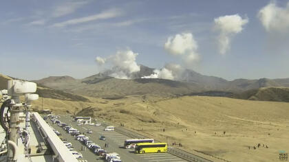
Mount Aso Nakadake and Takadake area is the difficult volcanic summit option when access is permitted. Routes vary with crater closures and trail status, but a common high-route outing is roughly 6-8 km / 3.7-5 mi with about 500-700 m / 1,640-2,300 ft of elevation gain, with exposed volcanic terrain and fast-changing conditions.
Mount Kuju is one of Kyushu's classic mountain hikes. A common Makinoto Pass route toward Kuju or Naka-dake is about 9-11 km / 5.6-6.8 mi round trip with roughly 600-750 m / 1,970-2,460 ft of elevation gain, depending on the exact summit and side trips.
Tadewara Marsh and Chojabaru walks are easier boardwalk and wetland routes in the Kuju area. Short loops can be about 1-3 km / 0.6-1.9 mi with little elevation gain, making them useful when higher ridges are windy, cloudy, icy, or closed.
Camping, Lodging, and Visitor Centers
The park is spread across several towns and volcanic districts. Visitors commonly base in Aso, Minamiaso, Kurokawa Onsen, Kokonoe, Taketa, Beppu, or Yufuin. Japan National Parks lists visitor information centers including Aso Volcano Museum, Aso Grassland Conservation Center, Chojabaru Visitor Center, Mount Aso Visitor Center, and Minamiaso Visitor Center.
Volcano Safety and Road Access
Mount Aso crater access can close because of volcanic gas, eruption risk, weather, road conditions, or visibility. If the crater road or trails are closed, use webcams and official pages to pivot toward Kusasenri, Daikanbo, Kuju, Tadewara Marsh, hot springs, or lower-elevation viewpoints.
Webcam Notes
Feed credit: WorldCam and RKK. The WorldCam card uses a preview image with a provider link for the current view. Additional Aso-area camera sources may come and go, so this page only displays sources that are currently usable on the site.