
Introduction
Bukhansan National Park rises along the northern edge of Seoul and into Gyeonggi Province, protecting granite peaks, forested valleys, historic temples, and the Bukhansanseong Fortress wall. The park was designated in 1983 and is managed by Korea National Park Service. Its main mountain area includes Baegundae, Insubong, and Mangyeongdae, while the Dobongsan area is another major hiking and climbing district.
For broader background, see the Bukhansan National Park Wikipedia page. For official planning information, use the Korea National Park Service Bukhansan page, KNPS Bukhansan trail course page, and VisitKorea Bukhansan page.
Top Hikes
Bukhansan is a city-edge mountain park, but the granite summit trails can be steep, polished, crowded, icy, or exposed. Check KNPS trail conditions, weather, seasonal closures, and daylight before starting.
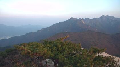
Baegundae Peak via Bukhansanseong is the classic difficult summit hike to the highest point in the park, 836.5 m / 2,744 ft. A common round trip is about 8.4 km / 5.2 mi with roughly 745 m / 2,445 ft of elevation gain, finishing with steep granite, stairs, and fixed handrails near the summit.
Dobongsan and Sinseondae is another popular rocky summit route in the park's Dobong area. A typical round trip from the Dobongsan Station area is about 7-8 km / 4.3-5 mi with roughly 650-750 m / 2,130-2,460 ft of elevation gain, with steep upper sections and wide views over northern Seoul.
Bukhansan Dulle-gil is the easier long-distance foothill trail around the park, linking forest paths, neighborhoods, cultural sites, and valley sections. The full route is about 70 km / 43.5 mi, but most visitors walk one or two shorter sections with modest elevation gain.
Camping and Lodging
Most visitors stay in Seoul and reach the park by subway, bus, taxi, or private vehicle. VisitKorea lists parking at Bukhansanseong Parking Lots 1 and 2 and Jeongneung Parking Lot, while KNPS should be checked for current facility, program, and reservation information.
Getting There
Bukhansan has several entrances, so route choice matters. Popular access points include Bukhansanseong, Jeongneung, Bukhansan Ui, and Dobongsan. Public transportation is usually the easiest option on busy weekends because trailheads and parking areas can fill early.
Webcam Notes
Feed credit: Nature Space TV, WorldCam, and NowJejuPlus. The YouTube video is included as a Bukhansan mountain view from the supplied source, while the WorldCam image is a preview with a link to the provider page for the current camera view.